

| Select a region: | Map of State of Kansas |
Natural Resources

The state of Kansas allocates its surface water and groundwater resources for the beneficial use of the public and the management of the resource for the use of generations of Kansans to come. There are a number of laws that guide the provision of water in Kansas, including the Kansas Water Appropriation Act, the Groundwater Management District Act, and the Kansas Water Banking Act. However, the Kansas Water Appropriation Act is the principal law under which water in Kansas is administered, managed, and regulated. The law is administered by the Division of Water Resources (DWR) within the Kansas Department of Agriculture. Under the Kansas Water Appropriation Act, it is illegal for individuals in Kansas to use water for other than domestic purposes without holding a water right from the DWR. Domestic use is defined as the use of water by any family unit for household purposes, watering farm and domestic animals, and watering lawns, orchards or gardens not exceeding two acres in size.1
Also see:
Water Access
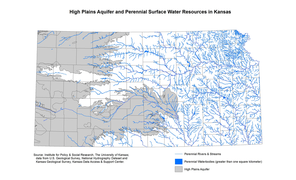
The means by which water is accessible varies throughout the state as a result of the three Köppen climate classifications present in Kansas. The parts of the eastern portion of the state experience significantly more rain than the semi-arid steppe climate found in the western portion of the state.2 As a result, much of the eastern portion accesses surface water and precipitation for agricultural, industrial, recreational, and municipal needs. The western portion of the state relies upon quickly depleting groundwater sources, such as the High Plain Aquifer, for mostly agricultural and industrial needs. The map below shows the High Plains Aquifer and all of the perennial surface water sources throughout the state.
Also see:
- [Map] Average Precipitation in Kansas, 1991-2020
- [Interactive Map] Rural Water District Maps (Kansas Rural Water Association)
Water Management
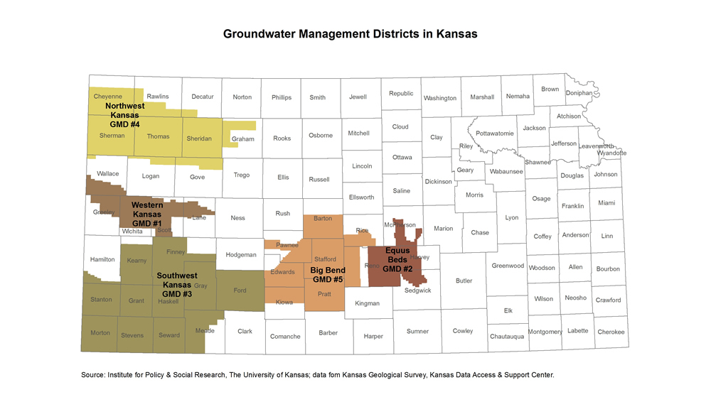
Water represents a crucial component of economic vitality in the state of Kansas. This is particularly true in the western half of the state where agriculture and industry form the foundation of economic activity. In order to most adequately meet the present demands for water while considering the state’s long-term economic needs, the state has implemented a number of tools for managing water resources:Groundwater Management Districts (GMD): In an effort to promote more localized management of water resources, the state of Kansas passed the Groundwater Management District Act. The Act sets forth the parameters by which Groundwater Management Districts are formed and their roles and responsibilities upon incorporation by the secretary of state. Groundwater Management Districts must create and implement a groundwater management program. Along with the management program, GMDs have the ability to levy water users charges and land assessments, issue general and special bonds, incur indebtedness, construct and establish research and development projects, seek and accept grants or other financial assistance, among many others. There are currently five GMDs in Kansas.3
Local Enhanced Management Areas (LEMAs): According the Kansas Senate Bill No. 310, voters and officials within a groundwater management district may initiate a local enhanced management plan if they recognize the need for more significant water management measures. Currently the only existing Local Enhanced Management Area is located in Sheridan and Thomas counties.4
Water Banking: The Kansas Water Banking Act allows for the creation of two water banks in the state. However, the Central Kansas Water Banking Association is currently the only water bank in the state. The Central Kansas Water Banking Association was established in order to relieve areas within the boundaries of the Groundwater Management District 5 that have highly stressed water resources allowing for the conservation of water. Very few water right holders have used the water bank to date. More information about the Central Kansas Water Banking Association can be found at http://www.gmd5.org/Water_Bank/.
Multi-Year Flex Accounts: The multi-year flex account is one additional tool used by the Division of Water Resources to conserve water throughout the state. A water right holder may apply for a multi-year flex account, which allows for the water user to pool their authorized quantity for five years. A user is then able to use their five-year total authorized quantity at any point-in-time during the five year period. Conservation is achieved if a water right holder saves water each year anticipating the potential need for the water in future years, and arriving at the end of the five year period with a surplus of water because of risk-management oriented water use. 5
Also see:
Water Restrictions
Kansas is a "first in time-first in right” state meaning that the ownership of a water right protects a water right holder’s use against all users who subsequently apply for and obtain a right. In times of shortage, having priority may mean that a water right holder has the ability to continue pumping while rights with junior status maybe told to cease or reduce pumping significantly. Finally, the requirement protects the state's resources from abuse today, so that tomorrow's citizens can be supplied as well. The following is a list of policies, restrictions, and regulations that dictate the use of water by water right holders:Intensive Groundwater Use and Control Area (IGUCA): Officials within a groundwater management district or the Chief Engineer may initiate proceedings for the establishment of an intensive groundwater use control area if they deem conditions warrant such action. A groundwater management district may be initiated based on either water quantity or water quality issues. There are currently eight IGUCAs in Kansas, all with varying levels of restriction and regulation. For example, the Burrton IGUCA still allows for the approval of new water rights after each application undergoes thorough assessment of its impacts on water quality in the region, while the Walnut Creek IGUCA is completely closed to new water rights and both junior and senior water right authorized quantities have been reduced. 6
Minimum Desirable Streamflow (MDS): Recognizing the need to correct for over appropriation of surface water rights and groundwater rights associated with river and stream alluviums, the Kansas legislature named 23 rivers and streams as susceptible to minimum desirable streamflow restrictions. If one of the 33 stream gages associated with the 23 rivers falls below the statutory threshold for minimum desirable streamflow for seven consecutive days or falls below the additional trigger values for the Lower Republican River, then all junior water rights tied to the river, directly or hydraulically, must cease irrigation practices. 7
Also see:
Notes:
1Northwest Kansas Groundwater Management District No. 4
2 The Köppen-Geiger climate classification.
3 Kansas Department of Agriculture, Division of Water Resources, Groundwater Management Districts.
4Kansas Department of Agriculture, Division of Water Resources, Local Enhanced Management Areas (LEMAs) .
5Kansas Department of Agriculture, Division of Water Resources, Multi-Year Flex Accounts.
6Kansas Department of Agriculture, Intensive Groundwater Use Control Areas Fact Sheet (PDF).
7Kansas Department of Agriculture, Division of Water Resources, Minimum Desirable Streamflow.