
|
• Total Population • Population by Race/Ethnicity • Population by Age • Median Age |
• Components of Population Change • Migration • Educational Attainment |
| Select a region: | Map of State of Kansas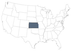 |
Demographics

Total Population
| Percent Change | |||||||
| Area | 2010 | 2020 | 2025 | 2010 - 2020 | 2020 - 2025 | ||
| Kansas | 2,853,118 | 2,937,880 | 2,977,220 | 3.0 | 1.3 | ||
| United States | 308,745,538 | 331,449,281 | 341,784,857 | 7.4 | 3.1 | ||
Source: U.S. Census Bureau: Decennial Census
Also see:
- [Map] Census Year of Maximum Population by Kansas County
- [Map] Percent Population Change in Kansas, by County
- [Map] Population Density in Kansas, by County
- [Map] Population Density Classifications in Kansas, by County
Population by Race and Ethnicity
| Race | 2010 | 2020 | Percent Change | |
| White | 2,391,044 | 2,222,462 | -7.1 | |
| Black or African American | 167,864 | 168,809 | 0.6 | |
| Other Race | 110,127 | 145,422 | 32.0 | |
| Asian | 67,762 | 86,273 | 27.3 | |
| American Indian and Alaskan Native | 28,150 | 30,995 | 10.1 | |
| Native Hawaiian and Other Pacific Islander | 2,238 | 3,412 | 52.5 | |
| Two or more races | 85,933 | 280,507 | 226.4 | |
| Ethnicity | ||||
| Hispanic or Latino | 300,042 | 382,603 | 27.5 | |
| Percent of Total Population | 10.5 | 13.0 | ||
Source: U.S. Census Bureau
Population by Age
| Age Group | 2010 | 2020 | Percent Change | |
| Age 0-4 | 205,492 | 179,446 | -12.7 | |
| Age 5-9 | 202,447 | 198,074 | -2.2 | |
| Age 10-14 | 198,884 | 208,847 | 5.0 | |
| Age 15-19 | 203,821 | 208,798 | 2.4 | |
| Age 20-24 | 204,454 | 202,972 | -0.7 | |
| Age 25-29 | 197,783 | 185,786 | -6.1 | |
| Age 30-34 | 179,937 | 189,855 | 5.5 | |
| Age 35-39 | 172,388 | 192,939 | 11.9 | |
| Age 40-44 | 174,285 | 174,026 | -0.1 | |
| Age 45-49 | 201,830 | 164,106 | -18.7 | |
| Age 50-54 | 204,434 | 165,359 | -19.1 | |
| Age 55-59 | 182,512 | 189,079 | 3.6 | |
| Age 60-64 | 148,735 | 188,203 | 26.5 | |
| Age 65-69 | 107,755 | 162,854 | 51.1 | |
| Age 70-74 | 82,634 | 126,077 | 52.6 | |
| Age 75-79 | 69,466 | 84,529 | 21.7 | |
| Age 80-84 | 56,943 | 56,133 | -1.4 | |
| Age 85 and over | 59,318 | 60,797 | 2.5 |
Source: U.S. Census Bureau
Also see:
Components of Population Change
Natural Change (births-deaths) | Net Migration (inflow - outflow) | |||
| Area | 2000-2010 | 2010-2020 | 2000-2010 | 2010-2020 |
| Kansas | 158,716 | 110,624 | 5,578 | -25,875 |
Source: calculated by the Institute for Policy and Social Research, The University of Kansas using data from U.S. Census Bureau
Also see:
- [Interactive Map] Census Flows Mapper (U.S. Census)
- [Interactive Map] Net Migration Patterns for US Counties (Applied Population Laboratory, University of Wisconsin-Madison)
Migration
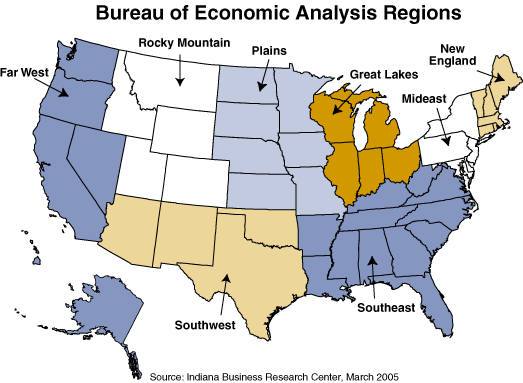
2015-19 County-to-County Migration by Region
[Click to enlarge]
States are grouped by BEA Region (http://www.stats.indiana.edu/maptools/maps/boundary/bea_regions.gif) with the exception of Colorado, Missouri, Nebraska, and Oklahoma which are shown individually.
Kansas counties that are not in an EDD (Brown, Douglas, Franklin, Jackson, Jefferson, Nemaha, Osage, and Shawnee) are shown combined with the MO-KAN counties (Atchison and Doniphan) as Northeast Kansas. A reference map of regions in Kansas is available in PDF and JPG.
Kansas counties that are not in an EDD (Brown, Douglas, Franklin, Jackson, Jefferson, Nemaha, Osage, and Shawnee) are shown combined with the MO-KAN counties (Atchison and Doniphan) as Northeast Kansas. A reference map of regions in Kansas is available in PDF and JPG.
Educational Attainment
Population age 25 and over
| Highest Completed Level | 2018 | 2023 | Percent Change | |
| Less than 9th grade | 69,212 | 66,345 | -4.1 | |
| 9th-12th grade, no diploma | 106,507 | 90,250 | -15.3 | |
| High school graduate, inc. equivalency | 492,819 | 495,115 | 0.5 | |
| Some college, no degree | 442,045 | 427,546 | -3.3 | |
| Associate degree | 161,016 | 174,373 | 8.3 | |
| Bachelor's degree | 394,462 | 425,528 | 7.9 | |
| Graduate or professional degree | 228,614 | 254,136 | 11.2 | |
| Percent completed high school or higher | 90.7 | 91.9 | 1.3 | |
| Percent completed bachelor's degree or higher | 32.9 | 35.2 | 6.9 | |
Source: U.S. Census Bureau
Also see: